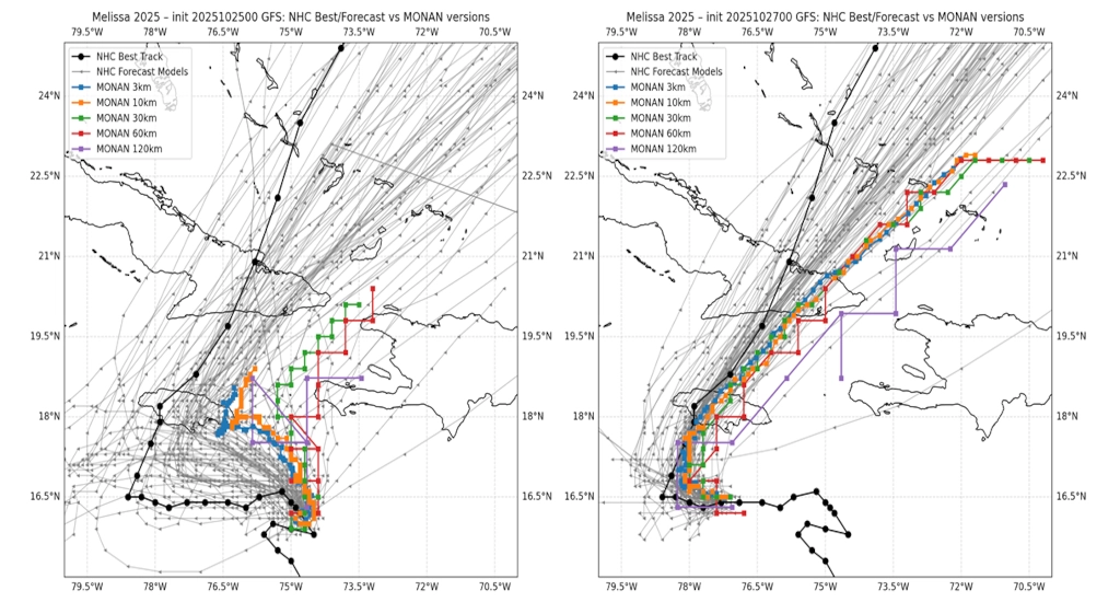
In a groundbreaking achievement, the National Institute for Space Research (Inpe), a research unit under the Ministry of Science, Technology, and Innovation (MCTI) of Brazil, has successfully conducted high-resolution global simulations at an unprecedented spatial resolution of 3 km using its Ocean, Land, and Atmosphere Predictions Model (Monan). These simulations were executed on the supercomputer Jaci and focused on extreme weather events, notably the Hurricane Melissa, which developed in the Caribbean Sea from October 25 to 27, 2025, undergoing a phase of rapid intensification.
According to Inpe, this execution of Monan at a 3 km resolution on a global scale is a significant technical milestone. It demands an immense computational capacity and efficient parallelization. The reduction in grid spacing to such a fine level necessitates highly capable equipment to manage the accelerated growth in the number of global points to be computed, as well as the frequency of model updates, thereby multiplying the computational cost.
Why 3 km Global Simulation Resolution Matters
The approximately 3 km range is often referred to as “convection-permitting” because it explicitly represents a significant portion of convective storms, reducing the reliance on parameterizations required for coarser grids. This improvement allows for a better description of intense and localized structures such as precipitation bands, squall lines, and extreme wind cores, which are critical for estimating risks related to flooding, landslides, and wind damage, especially during severe weather events.
In the context of tropical cyclones, this level of resolution supports a more realistic depiction of elements like wind field asymmetries, rain band organization, and the evolution of the convective core, all of which are directly linked to the storm’s intensity and potential for land impacts.
A Brazilian Model for 21st Century Climate Challenges
Monan stands as the first community-developed Earth system model tailored for the tropical and subtropical conditions of South America. Unlike generic global models, Monan is crafted by a broad Brazilian and Latin American scientific community, integrating coupled components of the Earth system — atmosphere, oceans, continental surface, and sea ice. Its development and implementation on the new supercomputing environment of Jaci aim to solidify Inpe’s operational and scientific capacity at both global and regional scales, directly enhancing the prediction of extreme events and supporting early warning systems.
From Testing to Continuous Forecast Improvement
Beyond the 3 km resolution test runs, Monan has commenced its regular operations at a 10 km resolution on the supercomputer Jaci. The ongoing advancements include increasing the resolution to a 3-5 km grid focused on South America and the Caribbean, alongside the introduction of an ensemble forecasting system. This system will provide a better quantification of uncertainty and reliability in forecasts, offering a range of possible scenarios to aid decision-making by civil defense agencies and climate-sensitive sectors.
The successful execution of these complex simulations on Jaci not only validates the supercomputer’s performance but also underscores the maturity and potential of the Monan model. This places Brazil at the forefront of high-resolution climate modeling and reaffirms Inpe and MCTI’s commitment to impactful science for society.
These developments are crucial as they equip Brazil and neighboring regions with advanced tools to anticipate and mitigate the effects of extreme weather, a growing concern in the face of 21st-century climate challenges. The continuous improvement of Monan’s predictive capabilities ensures that Brazil remains a leader in climate research and operational meteorology.
Source: Government
Like my content? Support me with a tip!