Global Positioning System (GPS) technology has become an indispensable part of our daily lives, guiding us through unfamiliar streets, helping us track shipments, and even assisting in search and rescue operations. But have you ever wondered how this remarkable system works? In this blog post, we’ll take a deep dive into the world of GPS, exploring its technology, functionality, and the science behind its incredible precision.
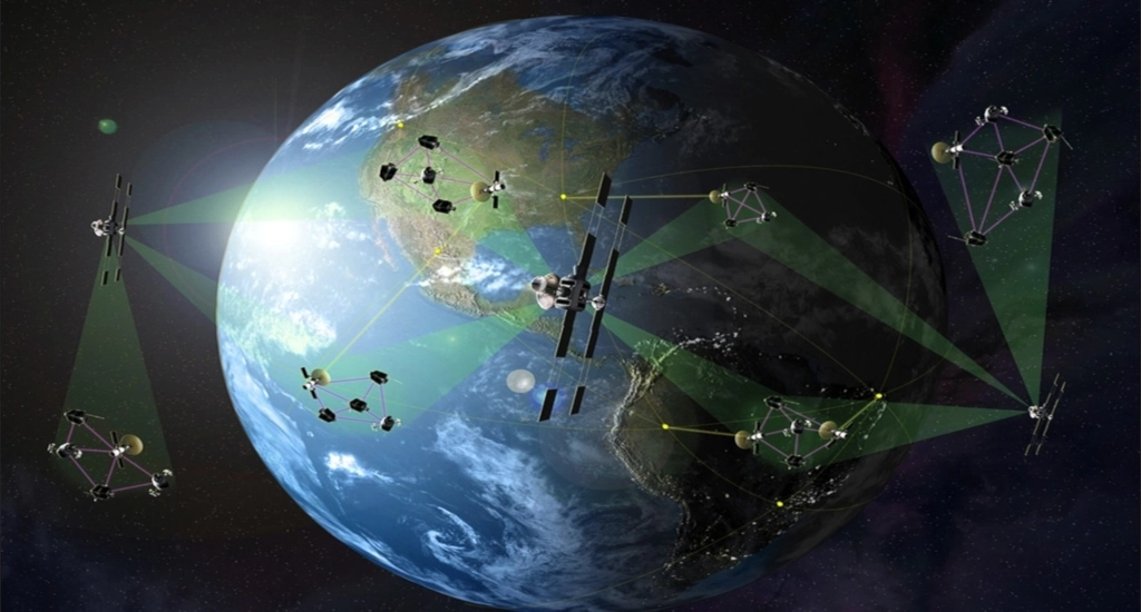
The Backbone of GPS: A Constellation of Satellites
At the heart of the GPS system is a constellation of at least 24 satellites orbiting the Earth. These satellites are maintained by the United States Department of Defense and are positioned in such a way that at least four satellites are always visible from any point on the Earth’s surface. Each satellite orbits the planet twice a day and is equipped with atomic clocks, which provide highly accurate time measurements.
The Three Segments of GPS
The GPS system consists of three main segments:
- Space Segment: This includes the satellites orbiting the Earth, which transmit signals with their current position and time.
- Control Segment: A network of ground-based stations around the world is responsible for monitoring the satellites, updating their clocks, and ensuring their proper functioning.
- User Segment: This is where your GPS device comes into play. It receives signals from the satellites and calculates your position.
How GPS Calculates Your Position
Your GPS device determines your location through a process called trilateration. Here’s how it works:
- Signal Reception: Your GPS device receives signals from multiple satellites. Each signal includes the time it was sent and the satellite’s current position.
- Time Difference: The device calculates the time it took for each signal to arrive. Since the signals travel at the speed of light (approximately 299,792 kilometers per second), the device can determine how far away each satellite is by multiplying the time difference by the speed of light.
- Intersection of Spheres: Imagine each satellite signal defining a sphere around the satellite. The point where at least three of these spheres intersect is your approximate location on Earth. This is trilateration in action.
- Fourth Satellite for Altitude: To get a more precise location, including altitude, your device uses a fourth satellite. This additional data point helps refine the position by correcting for any timing errors and providing the third dimension.
Can it be cut in ONE country?
While GPS signals CAN be blocked, it CAN’T be done through the satellites. To stop a country from having access to it, Jammers would be required, but even then it’d be unlikely to work, as:
- It would need to be installed INSIDE the target country.
- It would affect neighbour countries, creating diplomatic issues.
Because of that, even countries which are enemies of the U.S. such as Iran still have free access to it.
Correcting for Errors
Several factors can introduce errors into GPS calculations, including atmospheric conditions, signal reflections, and satellite clock discrepancies. To mitigate these errors:
- Differential GPS (DGPS): This system uses fixed, ground-based reference stations to broadcast correction data to GPS receivers, improving accuracy.
- Wide Area Augmentation System (WAAS): A set of satellites and ground stations that provide GPS signal corrections, which improve the accuracy of GPS devices to within a meter.
Other countries?
Other countries have developed their own satellite navigation systems similar to GPS. Here are the main ones:
- GLONASS (Russia): This stands for Global Navigation Satellite System. It was developed by Russia and provides global coverage just like GPS.
- Galileo (European Union): This is the EU’s version of a global satellite navigation system. It aims to be more accurate and reliable than GPS and GLONASS.
- BeiDou (China): China’s BeiDou Navigation Satellite System offers global services and is designed to be a complete alternative to GPS.
These systems work in much the same way as GPS, using satellites to provide location and timing information to receivers on the ground. They were created to reduce dependence on the U.S. GPS system and to offer more options and potentially better services worldwide.
The Ubiquity of GPS
GPS technology isn’t just in your car or smartphone. It’s used in a myriad of applications:
- Aviation: Pilots rely on GPS for navigation and landing procedures.
- Maritime: Ships use GPS to chart their courses across the vast oceans.
- Agriculture: Farmers employ GPS for precision farming, optimizing field usage and crop yields.
- Emergency Services: First responders use GPS to quickly locate and assist individuals in distress.
The Future of GPS
As technology advances, so does GPS. The next generation of GPS satellites, known as GPS III, promises even greater accuracy, better security, and enhanced anti-jamming capabilities. Moreover, the integration of GPS with other global navigation satellite systems (GNSS) like GLONASS, Galileo, and BeiDou will provide more comprehensive coverage and reliability.
Like my content? Support me with a tip!